Have you ever dreamed about an epic road trip? Embarking on a journey from Anchorage to Seward is a dream come true for any road trip enthusiast. The scenic drive from Anchorage to Seward offers breathtaking views of snow-capped mountains, crystal clear water, and lush forests that will astonish you with Alaska’s natural beauty. This incredible route, also known as the Seward Highway, is way more than just getting from one place to another. It’s a destination by itself, a journey of amazing beauty waiting to be explored.
This article will take you on a visual journey along this iconic route. Through a collection of photographs, you’ll experience this magnificent Alaskan landscape and discover some of the key highlights of the drive.
Get ready to capture the magic of this unforgettable road trip as you travel along one of the most scenic routes in the world!
Disclosure: Some of the links in this post may be affiliate links. If you decide to book through these particular links, we will receive a small commission from your purchase at no extra cost to you. We are truly grateful for your support!
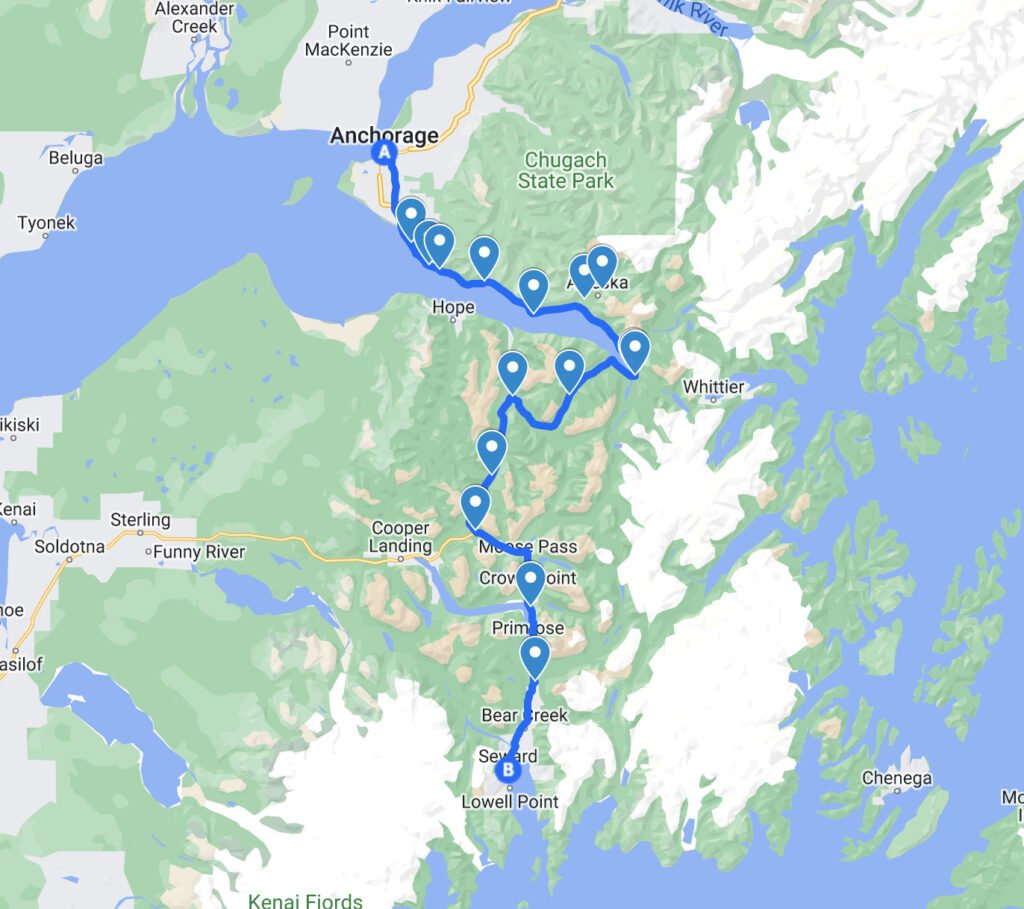
Route Overview
Length – 127 miles (204km)
Gas Stations – Don’t forget to refuel and pack some snacks and drinks. The only gas stations along the way are in Girdwood, Whittier, and Seward.
Please note – in the summer peak months, the gas station in Girdwood can become very busy. We recommend refueling in Anchorage.
Driving Time – During the regular workweek, driving from Anchorage to Seward directly usually takes 2.5-3 hours. However, on summer weekends, when the roads are filled with traffic and slow-moving RVs driving southward, that same journey can take significantly more time. We recommend taking your time to explore this magnificent area. If you can, we encourage you to make this journey over several days.
Cellular Coverage – Cellular coverage along the way may be poor in some areas. Make sure to look up directions and any information ahead of time. We also highly recommend downloading an offline map of the area.
Rest Areas – There are several rest areas and pullouts along the road. Most of them with stunning views. In some rest areas, a few primitive restrooms will be available.
Wildlife – Be prepared for wildlife – there is a possibility of encountering moose or other wild animals, so it is important to keep an eye out. Please see more information about driving in moose country here.
Embark On A visual Journey, Driving from Anchorage to Seward
Let us take you on a journey captured in photos through this stunning drive.
Step into the driver’s seat and traverse one of Alaska’s most magnificent roads.

Turnagain Arm
The route starts in Anchorage.
Driving Route 1 south, a short while after leaving Anchorage, the scenery of Turnagain Arm comes into view.

Turnagain Arm is a branch of Cook Inlet. It is a long and narrow bay stretched over about 40 miles (64 km), with a stunning coastline of snow-capped mountains sloping to the shores.
Seward Highway, passing along the coastline of Turnagain Arm, provides several scenic overlooks where you can pull off the road and enjoy the incredible views.

The arm is world-famous for the Alaska bore tide phenomenon.
This incredible natural wonder occurs when the leading edge of the incoming tide meets a powerful outgoing current. This collision forms a wave that surges upriver and into narrow bays.
Turnagain Arm holds the honor of being home to North America’s second-highest tides, with only those in Canada’s Bay of Fundy surpassing it.
Around new and full moons, the bore is more significant and it can even reach a height of 6-10 feet (1.5-3m)!
In the summer months, you can also enjoy watching experienced adventure seekers come to ride this massive wave on boards and kayaks!
Note!
The mudflats along Turnagain Arm can be treacherous, like quicksand! It is highly advised to stay off the shores and avoid walking on any of these mudflats. For your safety and protection, please enjoy viewing this coastal area from the designated viewpoints only.
Potter Marsh

The first stop on the way is Potter Marsh, which is a part of Anchorage Coastal Wildlife Refuge.
Potter Marsh is home to a variety of birds, including mallards, trumpeter swans, and bald eagles. Birdwatching is especially popular here in the summer months. The wildlife refuge is also a habitat for beavers, muskrats, and salmon running upstream in the late summertime, and if you are lucky, you may even see a moose!
Family-friendly boardwalks allow accessible wildlife viewing spots from a safe distance, without interfering with the wildlife. The marsh is an important part of the larger ecosystem and serves as a great place to explore nature and appreciate wildlife in its natural habitat.
Google Maps location
Estimated time: 1 hour
McHugh Creek Recreation Area

Going forward with the road, McHugh Creek Recreation Area is a scenic picnic area. With a small waterfall, hiking trails, picnic tables, and restrooms, it is a perfect place to stop.
You can appreciate stunning views of Turnagain Arm from the upper parking lot.
In order to get to the upper lot you can drive your car there, or you can park in the lower lot and climb up some stairs to the top lot.
Being part of Chugach state park, there is a fee of 5$ for parking and utilizing the facilities. Make sure to bring cash in advance.
Google Maps location
Estimated time: 15 minutes for taking in the views, more if you plan to hike.
Note!
When you’re exploring this area, it’s important to remember that this is a bear country. To stay safe while on a hike, be mindful of your surroundings and make plenty of noise! For extra safety measures, think about bringing along bear spray or some bear bells with you.
Beluga Point

Beluga Point Lookout, 1.4 miles (2.25km) from McHugh Creek Recreation Area, is one of the most popular stops on Seward Highway. In addition to an excellent viewpoint over Turnagain Arm, this is a great place for spotting the tidal bore at the right time.
Between mid-July and August, if you are lucky you may spot beluga whales coming in with the tide to feed on the salmon!
Be sure to enjoy this phenomenon from a safe distance, walking on the mudflats is extremely dangerous!
Google Maps location
Estimated time: 15 minutes to enjoy the stunning view, more if beluga whales are present or if you are at the right time for the tidal bore.

As you keep driving along the next 15 miles (24 km), there is a high chance of spotting dal sheep grazing in the mountains to your left.
Indian Valley Mine & Gifts


Indian Valley Mine is an excellent spot to explore. It is enjoyable and exciting for adults and kids alike.
The mine played a significant role in the early settling of Turnagain Arm.
Due to its historical significance, the main cabin and assay building have been designated as a National Historic Site. Today, you can visit both structures. The main cabin is now a gift shop while the assay building is home to a presentation of antique mining tools. For only $1 per person, you can explore this unique piece of history!
You can purchase dirt buckets of multiple sizes that contain a few small pieces of gold and precious stones, all the while learning how to pan for gold from the friendly and accommodating hosts.
Please see opening times and rates on Indian Valley Mine official website
Google Maps location
Estimated time: 1-2 hours
Tips:
If you are with young kids, bring change clothes. There is a chance they will get wet.
Bird Point


The next destination is Bird Point, which provides more breathtaking views of Turnagain Arm. Additionally, this spot is an ideal location for experiencing tidal bores – just remember to remain at a safe distance! The mudflats can be hazardous and should not be traversed on foot.
Google maps location
Estimated time: 15 minutes to enjoy the stunning view, more if you are at the right time for the tidal bore.
As you continue down the road, the majestic beauty of nature is all around.

When you get close to Girdwood, you will pass the Ghost Forest.
This forest is a reminder of the 1964 great Alaskan earthquake (magnitude of 9.2) when the ground elevation dropped dramatically below sea level and ocean saltwater flooded in, killing the trees.
This earthquake is the most powerful earthquake recorded in North American history and the second most powerful recorded in the world.

Girdwood

Girdwood is a peaceful resort town nestled between majestic Chugach mountains and surrounded by lush forests. It is a perfect destination for outdoor enthusiasts of all levels, offering amazing nature, many hiking trails, and multiple activities.
In the winter, it is a popular getaway for skiers and snowboarders.
Every year in July, the town hosts the well-known Forest Fair festival.
No matter what your budget is, you’ll find accommodations for every budget in this area. From campgrounds and RV parking to vacation rentals, bed-and-breakfasts, boutique inns, or even the luxurious Alyeska Resort. Additionally, there are several local restaurants and cafes to enjoy.
If you decide to split the journey of Seward Highway across several days, we highly recommend Girdwood as the place to spend the nights!
Alyeska Tram Ride is a great way to admire the Chugach Mountains.
During the tram ride, look down at the forest. If you are lucky, you may even spot a bear!
After a few minutes’ ride to the top of the mountain, you will be amazed by the snow-capped peaks surrounding you, together with the stunning sights of Turnagain Arm from above.
At the mountain summit, there is an observation deck, a restaurant, and hiking trails.
To get to the tram, park in the Alyeska Resort parking lot. The entrance to the tram is behind the hotel, to the left.
Google maps location
Estimated time: 2 hours
Here is our article about Girdwood and the tram ride.
Note!
When you’re exploring this area, it’s important to remember that this is a bear country. To stay safe while on a hike, be mindful of your surroundings and make plenty of noise! For extra safety measures, think about bringing along bear spray or some bear bells with you.

Tips:
Before leaving Girdwood, make sure you have enough fuel. This is the last chance to refuel until you reach either Whittier or Seward, depending on the direction you are going.
Towards the Tip of Turnagain Arm
Continue our journey southward, the Turnagain Arm and the surrounding mountains become increasingly stunning. The blue hues of the arm are majestic against the snow-capped Chugach mountain range, creating a breathtaking display of nature’s splendor.
As you approach the tip of Turnagain Arm, the landscape becomes even more dramatic. The views of the rugged coastline from this stretch of highway are truly one of a kind!


Alaska Wildlife Conservation Center

Our next destination is the Alaska Wildlife Conservation Center (AWCC). This wildlife sanctuary works to protect and preserve Alaskan wildlife, contributing through conservation, education, and research initiatives, as well as providing care for animals in need.
As you explore the AWCC, you’ll get to meet some of Alaska’s native wildlife. You can observe animals such as brown bears, black bears, bald eagles, caribou, moose, musk ox, and more in their natural habitat. AWCC offers guided tours and educational programming, providing visitors with a chance to learn more about the wildlife that inhabits Alaska’s natural landscape.
Google Maps location
Estimated time: 2 hours
For up-to-date information about operating hours and prices, please visit the official website.

Portage Valley

After visiting AWCC, continue driving on the Seward Highway. A short drive will bring you to a fork in the road, where Portage Glacier Rd branches from the Seward Highway. Here, you can turn left and take a side trip to Portage Valley and Whittier or continue forward in the direction of Seward.
Google maps location
Please see our guide for Portage Valley and Whittier for more information about this area.
Upon ending your journey in Portage Valley, return to Seward Highway (Rt 1) and drive towards Seward.

A short while after, you will enter the Kenai Peninsula.
Turnagain Pass
The road winds through Turnagain Pass, which is the highest point on Seward Highway (988 feet / 301m).
Turnagain Pass Rest Area is a nice place to stop, with picnic tables, restrooms, and short hiking trails. It’s a great spot to take a break from the drive. The hiking trails here are easy enough for beginners, with most of them accessible from the parking lot. You can also enjoy the peace and quiet of the Chugach National Forest while you’re here. If you’re looking for something a bit more challenging, there are several trails that lead to the surrounding alpine areas. Just be sure you bring plenty of water and snacks, as some of these runs can take a few hours.
Estimated time: 15 minutes. More if you decide to take a hike.


Canyon Creek
Canyon Creek Rest Area offers a remarkable opportunity to take a break and gain insight into the area’s history. With clean restrooms, informative historical signs, and an awe-inspiring lookout of the canyon valley below, it is truly worth visiting.

In 1895 gold was discovered beneath Canyon Creek Bridge. This sparked off an incredible stampede as more than 3000 gold seekers flocked in with hopes of getting rich. In order to provide for the influx of fortune hunters, several towns were hastily established around Turnagain Arm. In its early years, Canyon Creek yielded more gold than any other creek in the area.
Estimated time: 15 minutes
Google Maps location


If you would like even greater insight into the history, you may take a detour of 36 miles toward Hope. Hope is an iconic mining town of the Gold Rush era. It is a small town steeped in history and stories that have been passed down for generations. Today, Hope is a small community with unique local businesses and stunning beauty. The streets are lined with colorful log buildings ranging from the historic Hope Hotel to the Saloon and the general store. There is also a museum that documents the history of mining in Alaska.
The Pristine Wilderness of the Kenai Peninsula
Driving further will take you to the pristine wilderness of the Kenai Peninsula. This is a popular destination for outdoor lovers, offering magnificent hiking trails, cycling routes, fishing spots, rafting, kayaking, and many camping possibilities.
Together with the abundant wildlife and the breathtaking views of mountain ranges, glaciers, forests, and waterfalls that you can find here, it’s a perfect place to experience Alaskan nature at its finest.
Continue driving forward, and you will pass several lakes, with multiple pull-outs, where you can stop and enjoy the marvelous views.
Summit Lake
One of our favorites is Summit lake, surrounded by emerald-green mountains. This is a great place for a picnic, or for simply admiring the stunning landscape.
Summit lake lodge is also located here, and worth a stop for a bite to eat and some local souvenirs.
Please note the restaurant is open seasonally and not daily. Make sure to double-check the restaurant’s opening times if you plan on visiting.


At Sterling Highway Junction, you’ll depart Rt 1 and catch Rt 9 leading to Seward. Note that from then onward, the road is still called the Seward Highway.
Tern Lake
Right after the junction, you will reach Tern Lake, which is well-known for its crystal-clear reflections on bright days! You can stop at the Tern Lake pullover, for taking pictures or just admiring the scenery.


Moose Pass
Moose Pass is a small town along the road. You can stop at the Moose Drop-In Trading Post to buy up some unique souvenirs or try out their delicious fudge!
Kenai Lake

Kenai lake was formed from glacier water with ultra-fine silt, which gave it its majestic turquoise color. There are several pull-outs around the lake, where you can stop and admire the marvelous views.
Kenai Mountains – Turnagain Arm National Heritage Area Sign
The next few miles before reaching Seward will be filled with more spectacular views of the mountains on both sides of the highway.
About 12 miles before Seward, there is a particularly scenic roadside pull-out. A large plaque is standing there with the following quote printed upon it:
“There is one word of advice and caution to be given those intending to visit Alaska . . . If you are old, go by all means, but if you are young, wait. The scenery of Alaska is much grander than anything else of its kind in the world, and it is not wise to dull one’s capacity for enjoyment by seeing the finest first.”
Henry Gannett, Harriman Alaska Expedition, 1899
This is a great spot to get out, stretch your legs and treasure the beauty of your surroundings!


Seward
At last, the road ends up in scenic Seward.
Settled on the outskirts of Kenai Fjord National Park, Seward is an amazing destination in itself. It’s home to pristine beaches, historic landmarks, and plenty of activities for nature lovers.
Here, you can take a boat tour to the breathtaking glacier-filled fjord, and observe the abundant wildlife in their natural habitat, including whales, sea lions, and sea otters, and if you are lucky you can see some mountain goats or even a bear!

You can visit Exit glacier and explore its trails while admiring majestic natural views.
Exit glacier is the only glacier accessible by road in the entire Kenai Fjords National Park. For the past two centuries, Exit Glacier has steadily receded and lost a considerable mass of its former size. The retreat of this glacier is a warning sign of global climate change and serves as an important reminder to us all that we need to take action now in order to protect our environment.

You can enjoy the beautiful harbor, where you can find nearby art galleries, restaurants, and bars that serve freshly caught seafood.

Seward is also home to the Alaska SeaLife Center, where you can learn all about the local marine life and get close to puffins, seals, sea lions, and salmon.

And much more!
You can find more information in our article about Seward.
Related Articles
For more information, please see:
Our article about Kenai Fjords National Park
Our article about the 7.5h Kenai Fjords National Park Cruise
Thank you for taking the time to read this! If you have any questions or would like to share your experience, please leave us a comment below.
You can save this guide for later on Pinterest by clicking on the photo.


